tellicogregg
Member
- Joined
- Feb 25, 2014
- Messages
- 21
Durhamtown-Tellico
Postby lockedcj7 » August 1st, 2014, 3:22 am
Sorry to say, the old Tellico trail system remains closed.
Durhamtown-Tellico, however, is open for business! They have a great website that is up to date and accurate so I'll try not to repeat all the same info.
http://www.durhamtowntellico.com/
First Impressions: You won't stumble upon this park. From downtown Murphy, it's another 15 miles but the directions on the website will take you right to it. The parking lot is steep gravel with level terraces for loading and unloading if you're taking a trailer. The office cabin is new, clean and the staff was extremely welcoming and friendly. There were three other ATVs in the park (that I never saw) but otherwise, I had the entire place to myself. Because of that, I stayed off of the "difficult" and "extreme" trails, preferring to stay on the "easy" and "moderate" trails. For those of you who don't know my Jeep, it's an '85 CJ-7 on 33s. It has 4.10s, ARBs front and rear, winch, full cage, 1-piece axles, sway-bar disconnects and a MPFI 258. It's far from bullet proof but it will go anywhere I want to go without scaring the crap out of myself. The only reason I mention all that is to give you a frame of reference for my perceptions.
If you are familiar with Black Mountain, you'll feel right at home. The terrain is very steep and many of the roads are switchbacks carved into the sides of the mountain. The really narrow ones are marked "One Way" and that direction is usually UP. The first mile or so of trail looks to be new dozer work but gives way quickly to older Jeep trails and logging roads. There are four ponds (only saw two of them) and several open areas with lots of camping and picnic areas.
Overall, I thought it was great. I like trail riding with a few obstacles mixed in and that's exactly what I got. When (not if) I go back, I'll go with a group and try some of the harder trails. Still to come: I'll get the map out of the Jeep (when it stops raining) and give a brief description of each of the trails that I drove and a conclusion.
lockedcj7
Posts: 16
Joined: September 7th, 2012, 5:35 pm
Top
Re: Durhamtown-Tellico
Postby lockedcj7 » August 1st, 2014, 3:57 pm
Lucy Gap: Wide gravel road without any obstacles. This is the main road that gets you in and out of the park.
Plane Crash: One-way switchback trail that leads past a real plane crash site. A steep footpath leads down to the wreckage if you're feeling brave and you can read more about the crash in the park office. The road is wide enough to feel safe and no obstacles.
Ridge Road: Just what the name implies. There is one fairly steep section near the intersection of Plane Crash, Ridge Road and Rocky Road but otherwise no obstacles.
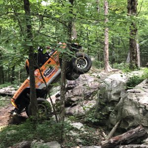
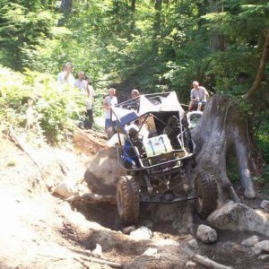
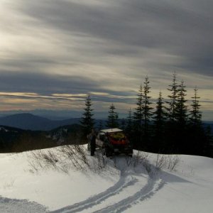
Buzzard's Roost: An easy trail that leads up to the Buzzard's Roost overlook. A loop goes through the campsite here with a good turn around at the end. The rock bald and view is well worth the short footpath it takes to get to it.
Image
Image
Image
Mossy Branch: Short, easy trail that connects Buzzard's Roost to Thrash Camp.
Thrash Camp: Longer easy trail that connects several other roads. I didn't follow it all the way since it appeared to be just more of the same easy road, connecting to another easy road called Plankroad Branch. I opted to take the Bridge Trail across Little Snowbird Creek (absolutely beautiful) to Little Snowbird Road. The campsites along the creek here looked awesome but I really didn't check them out. Maybe next time.
Gunstock Trail: I don't remember anything about this trail except that it must have been fairly easy. If I had more time, I would explore the Snowbird Clubhouse and surrounding area more here.
I drove around some of the difficult trails in the bowl area but managed to miss the play area. The signage in the park is very good but some logging in this area has resulted in some new trails that aren't too well marked. I thought I was on New Cut Road, which appears to be new as the name implies but I got turned around and ended up on Tom Taylor.
Tom Taylor is being used by the logging crews so it's an easy ride. I can see how it could get real muddy, real fast if it was raining. Most of this trail is level and wide.
I ended up on the Tellico Road and attempted to make it out to the end. This trail is 12 miles and leads out to two other tracts. Mostly easy, unimproved gravel but it does have a few rocky sections. I ran out of time and had to turn back before making it to the end. This is the road that connects to the old Tellico trail #6. If you like mile after mile of trail riding, this is the road for you. After that, I hauled butt back to Lucy Gap and out of the park. It took an hour and a half to make it from where I was on the Fain Tract back to the entrance.
lockedcj7
Posts: 16
Joined: September 7th, 2012, 5:35 pm
Top
Re: Durhamtown-Tellico
Postby lockedcj7 » August 1st, 2014, 6:16 pm
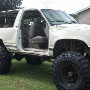
Lower Pond
Image
When I go back, I'll definitely plan to camp in the park. A night ride out the Tellico Road would be awesome and I wouldn't have to worry about getting back when the park closes. If I go by myself, I'll plan to fish and explore the cabins more as well as hit the easy and moderate trails that I missed. If we can get a group to go, I'll want to explore the Difficult trails. Overall, the park has a lot to offer and lots more potential.
In my humble opinion, it needs trails between "Moderate" and "Difficult". The Moderate trails were too easy and the Difficult trails looked too gnarly, certainly to attempt without the buddy system. If they will stop trying to maintain the Moderate trails, they will probably get more difficult with time and wear. I had the same complaint, if you can call it that, about Black Mountain.
lockedcj7
Posts: 16
Joined: September 7th, 2012, 5:35 pm
Top
Re: Durhamtown-Tellico
Postby jcopel » August 3rd, 2014, 4:32 am
Hey Man. Thanks for all the information. Awesome job with the write-up.
We need to get out for a couple of trips this fall. One day trip and one extended trip. We're thinking Crossroads Mtn for a day trip and URE or this for an extended trip. Is this mostly tent camping, or do you think I could pull my pop-up to a decent spot?
These are some beautiful photos and thanks so much for the write-up. Let's definitely try to get up here real soon.
What part of "...the right of the People to keep and bear arms shall not be infringed" do you not understand?
User avatar
jcopel
Posts: 743
Joined: June 3rd, 2011, 2:46 am
Location: Upstate, SC
Top
Re: Durhamtown-Tellico
Postby lockedcj7 » August 3rd, 2014, 6:46 pm
Thanks for the kind words. Towing a pop-up with a Jeep to the Upper and Lower Ponds would be totally doable. Lucy Gap and Little Snowbird roads are wide and easy. Lucy Gap has some steep sections and switchbacks but no big rocks or obstacles to get hung up on. I think approaching the camping and cabin areas on the Bridge Trail from the west would also be pretty easy.
I'm stoked to go again and I'll go anywhere everyone else wants to go. URE is technically further away but it's mostly interstate so the time probably works out the same.
lockedcj7
Posts: 16
Joined: September 7th, 2012, 5:35 pm
Postby lockedcj7 » August 1st, 2014, 3:22 am
Sorry to say, the old Tellico trail system remains closed.
Durhamtown-Tellico, however, is open for business! They have a great website that is up to date and accurate so I'll try not to repeat all the same info.
http://www.durhamtowntellico.com/
First Impressions: You won't stumble upon this park. From downtown Murphy, it's another 15 miles but the directions on the website will take you right to it. The parking lot is steep gravel with level terraces for loading and unloading if you're taking a trailer. The office cabin is new, clean and the staff was extremely welcoming and friendly. There were three other ATVs in the park (that I never saw) but otherwise, I had the entire place to myself. Because of that, I stayed off of the "difficult" and "extreme" trails, preferring to stay on the "easy" and "moderate" trails. For those of you who don't know my Jeep, it's an '85 CJ-7 on 33s. It has 4.10s, ARBs front and rear, winch, full cage, 1-piece axles, sway-bar disconnects and a MPFI 258. It's far from bullet proof but it will go anywhere I want to go without scaring the crap out of myself. The only reason I mention all that is to give you a frame of reference for my perceptions.
If you are familiar with Black Mountain, you'll feel right at home. The terrain is very steep and many of the roads are switchbacks carved into the sides of the mountain. The really narrow ones are marked "One Way" and that direction is usually UP. The first mile or so of trail looks to be new dozer work but gives way quickly to older Jeep trails and logging roads. There are four ponds (only saw two of them) and several open areas with lots of camping and picnic areas.
Overall, I thought it was great. I like trail riding with a few obstacles mixed in and that's exactly what I got. When (not if) I go back, I'll go with a group and try some of the harder trails. Still to come: I'll get the map out of the Jeep (when it stops raining) and give a brief description of each of the trails that I drove and a conclusion.
lockedcj7
Posts: 16
Joined: September 7th, 2012, 5:35 pm
Top
Re: Durhamtown-Tellico
Postby lockedcj7 » August 1st, 2014, 3:57 pm
Lucy Gap: Wide gravel road without any obstacles. This is the main road that gets you in and out of the park.
Plane Crash: One-way switchback trail that leads past a real plane crash site. A steep footpath leads down to the wreckage if you're feeling brave and you can read more about the crash in the park office. The road is wide enough to feel safe and no obstacles.
Ridge Road: Just what the name implies. There is one fairly steep section near the intersection of Plane Crash, Ridge Road and Rocky Road but otherwise no obstacles.
Buzzard's Roost: An easy trail that leads up to the Buzzard's Roost overlook. A loop goes through the campsite here with a good turn around at the end. The rock bald and view is well worth the short footpath it takes to get to it.
Image
Image
Image
Mossy Branch: Short, easy trail that connects Buzzard's Roost to Thrash Camp.
Thrash Camp: Longer easy trail that connects several other roads. I didn't follow it all the way since it appeared to be just more of the same easy road, connecting to another easy road called Plankroad Branch. I opted to take the Bridge Trail across Little Snowbird Creek (absolutely beautiful) to Little Snowbird Road. The campsites along the creek here looked awesome but I really didn't check them out. Maybe next time.
Gunstock Trail: I don't remember anything about this trail except that it must have been fairly easy. If I had more time, I would explore the Snowbird Clubhouse and surrounding area more here.
I drove around some of the difficult trails in the bowl area but managed to miss the play area. The signage in the park is very good but some logging in this area has resulted in some new trails that aren't too well marked. I thought I was on New Cut Road, which appears to be new as the name implies but I got turned around and ended up on Tom Taylor.
Tom Taylor is being used by the logging crews so it's an easy ride. I can see how it could get real muddy, real fast if it was raining. Most of this trail is level and wide.
I ended up on the Tellico Road and attempted to make it out to the end. This trail is 12 miles and leads out to two other tracts. Mostly easy, unimproved gravel but it does have a few rocky sections. I ran out of time and had to turn back before making it to the end. This is the road that connects to the old Tellico trail #6. If you like mile after mile of trail riding, this is the road for you. After that, I hauled butt back to Lucy Gap and out of the park. It took an hour and a half to make it from where I was on the Fain Tract back to the entrance.
lockedcj7
Posts: 16
Joined: September 7th, 2012, 5:35 pm
Top
Re: Durhamtown-Tellico
Postby lockedcj7 » August 1st, 2014, 6:16 pm
Lower Pond
Image
When I go back, I'll definitely plan to camp in the park. A night ride out the Tellico Road would be awesome and I wouldn't have to worry about getting back when the park closes. If I go by myself, I'll plan to fish and explore the cabins more as well as hit the easy and moderate trails that I missed. If we can get a group to go, I'll want to explore the Difficult trails. Overall, the park has a lot to offer and lots more potential.
In my humble opinion, it needs trails between "Moderate" and "Difficult". The Moderate trails were too easy and the Difficult trails looked too gnarly, certainly to attempt without the buddy system. If they will stop trying to maintain the Moderate trails, they will probably get more difficult with time and wear. I had the same complaint, if you can call it that, about Black Mountain.
lockedcj7
Posts: 16
Joined: September 7th, 2012, 5:35 pm
Top
Re: Durhamtown-Tellico
Postby jcopel » August 3rd, 2014, 4:32 am
Hey Man. Thanks for all the information. Awesome job with the write-up.
We need to get out for a couple of trips this fall. One day trip and one extended trip. We're thinking Crossroads Mtn for a day trip and URE or this for an extended trip. Is this mostly tent camping, or do you think I could pull my pop-up to a decent spot?
These are some beautiful photos and thanks so much for the write-up. Let's definitely try to get up here real soon.
What part of "...the right of the People to keep and bear arms shall not be infringed" do you not understand?
User avatar
jcopel
Posts: 743
Joined: June 3rd, 2011, 2:46 am
Location: Upstate, SC
Top
Re: Durhamtown-Tellico
Postby lockedcj7 » August 3rd, 2014, 6:46 pm
Thanks for the kind words. Towing a pop-up with a Jeep to the Upper and Lower Ponds would be totally doable. Lucy Gap and Little Snowbird roads are wide and easy. Lucy Gap has some steep sections and switchbacks but no big rocks or obstacles to get hung up on. I think approaching the camping and cabin areas on the Bridge Trail from the west would also be pretty easy.
I'm stoked to go again and I'll go anywhere everyone else wants to go. URE is technically further away but it's mostly interstate so the time probably works out the same.
lockedcj7
Posts: 16
Joined: September 7th, 2012, 5:35 pm