crash2
-Oh no I picked a side-
I recall the lost lake turnoff prior to the region meadows turn off heading tor wards the ridge. It dropped immediately as you turned off the main trail. Is that trail open or closed?
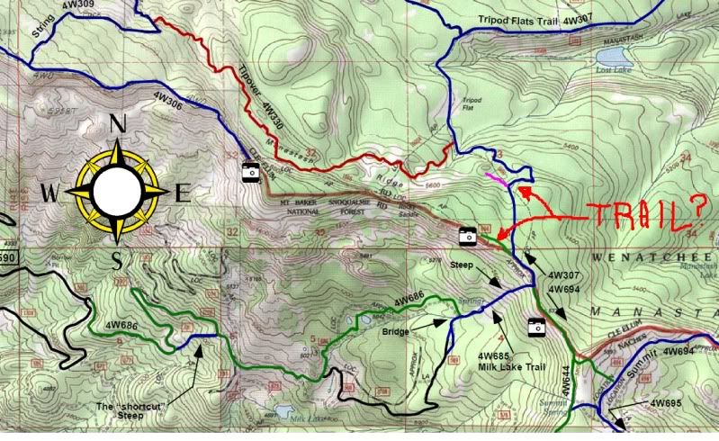
The overlook trails. Both dead ends. Didnt seem like the "purple" one was that far from the "green" one though
Maybe Murk will chime in here soon. I dont think theres a loose rock up there that he dosent know where it is or where it was.:redneck:
I was up there Saturday.
The blue trail does head downhill.
It also does run into a bunch of loose shale rock in a little open area on a downhill slope. By looking at the map, I would guess we turned around pretty close to the pink line/trail on your map.
We stopped there, turned around and went back.
A couple rigs past us, sounded like they were having some issue just past where we turned around...they ended up turning around and coming back.
A guy in a nice green runner with 2 stock roll bars and a spare tire attatched was the one who past us at the loose shale rock, then eneded up turning back around. He might know.
It also shows a dashed line (ATV or dirtbike) trail linking to the end of the manastash trail....heading across the rocky saddle...:eeek:
We came from Funny Rocks.
Took 694 trail, then it seemed to just merge into the 4W307. I dont recall any other trails, or at least what looked to be trails off the 4W307 before we turned around.

The old 601 trail you guys refer to is the current 330 trail. The trail was closed years ago due to the steep hill you refer to. The Wandering Willys Jeep club through the PNW re-routed the trail around the closed area to reopen it somewhere close to 15 years ago now. I was part of that process.
I don't know of any trails out of Tripod flats and unless it's a marked trail don't run it. There were issues last year with people making illegal trails out of the meadow and the USFS is looking at options now with how to deal with people going off trail in the meadow. It's beyond me why people can't follow a simple two track through a meadow.
The 601 (downhill only) section was closed and put to bed many years ago. Three deaths on that section was the reason. The Wandering Willy's Jeep Club was contacted by the USFS to reroute the trail thru where it is now. Sometime around that time the boundrys of the FS Districts were corrected and the 600 #'ers were switched to 300 series which is the Cle Elums numbers. The 601 is now Pucker Ridge in the Rimrock area.
Everyone should note that an existing Travel Plan exist in the Manastash area (for over 15 years) of the Cle Elum District. No new trails may be constructed. No vehicles of any type may be off of designated trails ( you may pull off to allow others to pass 1 vehicle width only). Construction of a bypass is not allowed. Use of a bypass constructed by others is not allowed. To mention a few.
From time to time we repost the rules on the kiosk's at Riders camp and Manastash campgrounds. Next time I get near my folders with the Forest orders I'll post them and have them sticky'ed.
So off the end of Manastash is where these occured?
On the 601.......
It was never part of the trail but people started using it during snow season because they did not find the real trail.
Oh, I thought the nasty drop-off and turn at the bottom was at the end of the manastash ridge...
On the 601.......
That purple line looks like where you come down the ridge and make the hard right in the puddle, i have seen tracks in snow season going straight over that drop off and back into the trail at the bottom. It was never part of the trail but people started using it during snow season because they did not find the real trail. The green line looks to be the trail out to the look out over the saddle on the one side, there was never a trail off of that.