Its frozen. Mud isnt a real issue. But better hope you have some big time dif. clearance if ur gonna dip in any holes... But i agree just get out their and find out for your self..Enjoy our ORV trails and respect the land.
-
Help Support Hardline Crawlers :
You are using an out of date browser. It may not display this or other websites correctly.
You should upgrade or use an alternative browser.
You should upgrade or use an alternative browser.
How difficult are the trails at elbe now?
- Thread starter slideshow86
- Start date
HotRodJosh
Well-Known Member
- Joined
- Nov 21, 2008
- Messages
- 511
I just joined the forum and dont want to get out there and hold a bunch of people up. Just kinda getting a feel for the area.
.
Hey man...I amy go up there next weekend...either Fri or Sat. I usually have my son with me and no other rigs, so I take it fairly easy.
You and yer pals are more than welcomw to tag along.:beer:
as everyone is saying, go find out, its really not a hard orv area. you will be suprised on how capable a stock rig is with a decent driver and some common sense. you will be fine. bring a come along just in case, but i doubt youll even need that :awesomework:
Ty.
Well-Known Member
Busy Wild seemed easier than normal becouse most of the ground was frozen.
Busy Wild seemed easier than normal becouse most of the ground was frozen.
Whats up. You should have fallowed us. Some entertainment was just around the corner. That was way cool for you to offer up your gloves.. I should have took you up on it we did some standing around and some winching.. But every thing drove out on its own power for once.....
CHOP SHOP
Well-Known Member
But every thing drove out on its own power for once.....
:clappy:
Ty.
Well-Known Member
I wanted to keep wheelin, but was running out of propane. We saw the mudhole swimmer back at the truck on our way out. It sounded like fun.
I wanted to keep wheelin, but was running out of propane. We saw the mudhole swimmer back at the truck on our way out. It sounded like fun.
We got some pics ill will have the club members post them soon. Send me a PM next time you go we can run some trails together.
Ty.
Well-Known Member
We got some pics ill will have the club members post them soon. Send me a PM next time you go we can run some trails together.
Will do.:awesomework:
Here's what I have for the Elbe GPS mapping so far. My GPS is accurate to within 7-10 feet. I didn't get everything done and there are some little offshoots and such that I've not mapped yet, such as the mid-trail access to Sunrise, Gotcha and Easywild. I also didn't get one little section of Mainline where it crossed the road for about 100 ft of DEEP water holes. I wasn't in the mood to spend another day playing SS icebreaker in bottomless pits just to map 100 yds of trail.
You should be able to load these up on a Garmin GPS and if you have the topo software then the map should load as well.
http://216.240.159.209/ORV.zip
I'll be putting the rest on this file eventually as well as Evan's Creek and maybe Tahuya, if I can ever figure out where I'm actually at while I'm out there...
Hmmm, don't know why the linky no worky, but I'll finger it out.
Well, apparently it just didn't like the file extension so I zipped it.
Last edited:
slideshow86
Well-Known Member
Here's what I have for the Elbe GPS mapping so far. My GPS is accurate to within 7-10 feet. I didn't get everything done and there are some little offshoots and such that I've not mapped yet, such as the mid-trail access to Sunrise, Gotcha and Easywild. I also didn't get one little section of Mainline where it crossed the road for about 100 ft of DEEP water holes. I wasn't in the mood to spend another day playing SS icebreaker in bottomless pits just to map 100 yds of trail.
You should be able to load these up on a Garmin GPS and if you have the topo software then the map should load as well.
http://216.240.159.209/ORV.zip
I'll be putting the rest on this file eventually as well as Evan's Creek and maybe Tahuya, if I can ever figure out where I'm actually at while I'm out there...
Hmmm, don't know why the linky no worky, but I'll finger it out.
Well, apparently it just didn't like the file extension so I zipped it.
This Rocks! I have a Garmin colorado 2 I think. That thing gets used soo much...
Thanks :awesomework:
(PS Do you know how to convert the file to a gpx format?)
I printed off a map of the area and figure ill go check it out soon. I think next sunday a friend and I are going to go find some snow since I didnt get out this weekend to test my locker.
Last edited:
A friend of the family runs this site and has all sorts of GPS stuff for all the trails in WA and Oregon http://www.nwjeepn.com/WAtrails.htm
This Rocks! I have a Garmin colorado 2 I think. That thing gets used soo much...
Thanks :awesomework:
I printed off a map of the area and figure ill go check it out soon. I think next sunday a friend and I are going to go find some snow since I didnt get out this weekend to test my locker.
That is not complete yet. It doesn't have the Alder Loop, Busy Wild or Swamp Trail yet. I'll get those on the next trip out.
I have to figure out how to get things like various legal bypasses and alternate exits connected, but I'm sure I'll figure that out eventually.
A friend of the family runs this site and has all sorts of GPS stuff for all the trails in WA and Oregon http://www.nwjeepn.com/WAtrails.htm
I had a laugh when he wrote that GPS mapping Elbe was next to impossible unless the trails were dry
")
graysquirrel
Well-Known Member
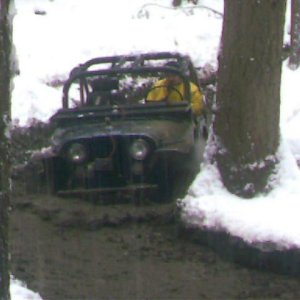
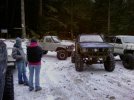
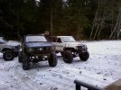
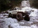
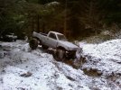
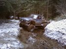
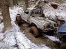
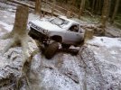
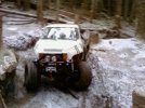
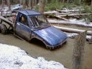
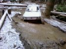
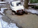
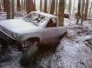
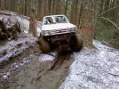
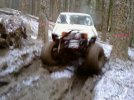
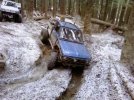
Heres what Elbe looks like right now, everything is pretty frozen but hardly any snow yet:booo:. Me and a few friends went on sunday, did sunrise (trail repair looks great!) part of mainline and the busywild. We were the first ones thru, breaking the ice on all the mud holes! Cold but fun trip.
Attachments
graysquirrel
Well-Known Member
graysquirrel
Well-Known Member
slideshow86
Well-Known Member
Great pictures!
Looks pretty sloppy out there :beer:
Looks pretty sloppy out there :beer:
Similar threads
- Replies
- 25
- Views
- 3K