• Help Support Hardline Crawlers :

Jeep Cross, Walker Valley...

boardbysled

Tree Nerd.
Joined
Jun 10, 2009
Messages
4,467
Location
NW Oregon
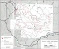
...is dangerous! It was previously marked closed because of logging operations in the area. The logging has destroyed a section of the trail, making it a very dangerous area. It should be marked with trail closed signs now.
 
As much as I hate to agree......I do agree.

And to clarify......it's just the "road" that is dangerous, not the "trail". The actual trail is as fun (and safe) as it ever was.:awesomework:
 
What in particular is "Dangerous" about it? And I've never seen "Jeep Cross" on the Walker map, where is it?
 
you know there has always been logging at walker.. and lots of trails have been closed after this...

if we are reclaiming the old trails at walker then we should reclaim them all!!!

look at old walker maps you will see.. plus i can still tell where some of the old trails near cavanaugh rd used to be.. we have lost more trails up there then most know about..


it will be like reiter in no time at this rate CLOSED!!! and i cant wait to thank those asshats who drive a distance to ruin the only orv park in my area...
 
I agree there are LOTS of old trails out there (fun ones too I might add!), but with the new rules popping up, and folks that can't seem to grasp that blazing trails/bypasses does hurt our area:booo:;
Things like this happen---just need to get a handle on what we currently have, then move for more mileage once it's been proven the existing system can be managed, by us the volunteers!!!! I want more trail too!
 
What in particular is "Dangerous" about it? And I've never seen "Jeep Cross" on the Walker map, where is it?

It's on there....technically it's Upper Mainline, and the spot in question is where the loggers drug trees down from above, taking a portion of the trail side with them (the trees)...
 
What do you mean? People shouldn't travel to an ORV area?
I don't understand what you mean?....

x2 and i do travel from spokane to walker,elbe,rieter when it was open and i will be traveling to evan`s, creek and other`s, I just think You should be more clear, and be careful who You are attacking , when You don`t even know. I personally believe it is your local nothing better to do hood looms. SAVE THE TRAILS, and watch who You point fingers at it may just be a partner in saving them rather than an enamey against them:mad: then again maybe you won of hose that really on the other side?
 
Yes, Ron's Run is it's new name...and BR34 is a part of it...the new signage isn't done yet that I know of...so now the sign on P.Burns rd is Upper Mainline last I saw...
 
Yal can find it on this map. Not sure what year this map is but its there. Really bad res on the pic too.
 

Attachments

  • Walker_Valley_Map.jpg
    Walker_Valley_Map.jpg
    70.1 KB · Views: 166
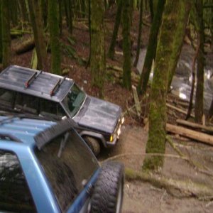
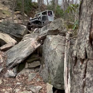
Wasn't jeep cross the trail that shot up off the road with the bricks in the ground/very steep?

And wasn't the ho-chi min trail the one that dumped you on the paved road?
 
Pretty sure in the ledger it states '95 or something like that....That not THAT old!!!:redneck::haha:
 
Top