Woodcutter's Pass! 25 miles, at least 15miles in low range

Hardline Crawlers - Rock Bouncer Builds, Tech & Off-Road Trail Talk

Help Support Hardline Crawlers:

rooinater

Well-Known Member
Joined
May 15, 2006
Messages
1,310
Reaction score
0
City & State/Province
Gig Harbor, WA
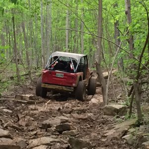
well hunting around and stumbled across this trail. what a blast! i wouldn't reccomend it for fullsizes, (but possible) there was some really tight spots, one rolled over suburban in a wash, a couple stripped and dead broncos and another stripped out suburban. the trail took about 6+ hours start to finish with no breakdowns or stucks. a few narrow shelf roads, a couple short jaunts off to a mine, and plenty of rocks. so here's a few pics of the trail.
1.jpg

2.jpg

3.jpg

4.jpg

5.jpg

6.jpg

7.jpg

8.jpg

9.jpg

10.jpg
 
still in yuma till july 4th, independence day i'm out on terminal leave from the marine corp and headed to washington.

the trail is just south east of yuma, az in the barry m goldwater air force range. it cuts through the gila mountains just north of the foothills mine. there's another mine or 2 along the trail. there's plenty of more difficult options. the trail weaves across a wash and sometimes stays in it. the actual wash would be extremely difficult in spots. there's one off shoot on a shelf road to a mine, then a narrow pass in the middle of the trail. if you want gps coordinates i can pull some off of topozone. the trail is difficult to find from east to west, but we ran it from west to east, and is pretty much straight forward to find. the range does require a free range pass though.
http://www.topozone.com/map.asp?lat=32.55184&lon=-114.30382&s=200&size=l&u=4&datum=nad27&layer=DRG
 
Last edited:
still in yuma till july 4th, independence day i'm out on terminal leave from the marine corp and headed to washington.

the trail is just south east of yuma, az in the barry m goldwater air force range. it cuts through the gila mountains just north of the foothills mine. there's another mine or 2 along the trail. there's plenty of more difficult options. the trail weaves across a wash and sometimes stays in it. the actual wash would be extremely difficult in spots. there's one off shoot on a shelf road to a mine, then a narrow pass in the middle of the trail. if you want gps coordinates i can pull some off of topozone. the trail is difficult to find from east to west, but we ran it from west to east, and is pretty much straight forward to find. the range does require a free range pass though.
http://www.topozone.com/map.asp?lat=32.55184&lon=-114.30382&s=200&size=l&u=4&datum=nad27&layer=DRG

My grandparents live in Yuma for half the year (snow birds) might have to make a road trip to visit them at hit this up looks like a fun trail
 
My grandparents live in Yuma for half the year (snow birds) might have to make a road trip to visit them at hit this up looks like a fun trail

well if you plan on coming down, let me know. not this fall but the following fall. i'm planning on towing the yota down, and doing the harder lines.
 
How long will you be stationed in Yuma? We might have to hook up sometime not in the summer. :redneck:
 
Everytime I see someone's built Subaru wagon, I wish I had kept mine from 10 years ago...

How the heck do you raise it up like that?
 
How long will you be stationed in Yuma? We might have to hook up sometime not in the summer. :redneck:

13 days, till july 4th. i've been here for almost 4 years, minus about 2 years of deployments. not this coming fall but next fall i want to come back to az to run the terminaters and a few other trails i have on my list to run. but i'll be bringing the yota.
 
Do you have any pics of the stripped out cars? Nice pics though!
Cory,

i think there's one of the bronco's in the back of a pic. but, no we didn't take any pics of the abandoned or rolled vehicles. tomorrow i'll go over to my buddies house and see if there's anymore good pics. i was driving the other 2 guys had passengers/photographers.
 
Back
Top