• Help Support Hardline Crawlers :

Manastash Ridge Trail - curious...

JThompson

Well-Known Member
Joined
Sep 6, 2006
Messages
833
Location
Sultan
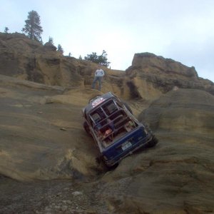
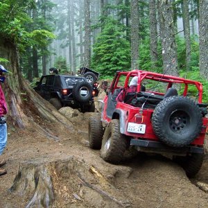
A few weeks ago, a few friends of mine, including that jackass Boonie Buster, went camping/wheeling over on the Ellensburg side of Manastash for the first time. We had done the Naches side many times before. We ran the Tripod Flats Trail to its junction with others on top of the ridge, then back down to Tipover, which we ran about 2/3 the way to Shoestring Lake (hit snow).
We noticed that off of Tripod, about halfway between the cabin and the top of the ridge, a faint (steep) trail took off down the mountain into a bowl, then continued into the brush. I wonder if anybody has ever ran from Tripod to the dead-end of the Manastash trail. When I hiked off the Tripod, down the steep hill, and followed the dim TSL tracks through the forest, and between the sawed/downed logs, I wondered if this was a past trail??? Downed logs were purposely cut about rig width... ??? Just curious.
 
On this map the area in question is if you start from where 4W307, 4W685 and 4W694 intersect and head back down tripods towards tripod flats. there is a green line that heads off the left side like a trail, we're wondering if that connects to manastash or if it's even possible, ALSO, the trail JThompson is talking about is where the trail makes a sharp 90* right turn, it looked like a trail went off the hill there. obviously it's not mark but there were definite marks as though it was a developed trail at one time. It could have been that green little offshoot, but that is the area that we saw it at.

http://nwjeepn.com/Maps/Shoe-Tripod-Tipover.pdf


Basically, is there a trail that connects from the end of Tripod to Manastah Ridge?
 
Only trail that comes to mind is the old 601 that used to go from near rocky sadle down..

That might be it, whatever it was it went down and quick from the the Tripod trail, it was near a pretty significant "puddle" on the trail at the bottom of a turn....i know it's vague, but it's really the only big water part of the trail towards the top. sound familiar?! :corn:
 
I had found the bottom of the 601 by mistake on one of my solo adventuers.

I took the trail at the tee above tripod flats (mainline to the rocks from buck medows). That trail will take you to either the top of the ridge near rocky sadle or the edge of the 4x4xnw rock garden at the tee before you start to shoot up the ridge. The 601 popped out prior to the tee but you had to take a short dead end trail to find it.

The 601 popped out on one of those rocky hill sides into a grassy area.

I waled up it a bit and damn it was steep (just heard the stories from mark wade about it) and was also known as the one way hill.
 
610, Huh? Any older maps that show it? I guess I am a little unsure if this is the same trail I am thinking of. But, Rocky Saddle would be the desired result.
 
610, Huh? Any older maps that show it? I guess I am a little unsure if this is the same trail I am thinking of. But, Rocky Saddle would be the desired result.

no--the 601 :redneck:

I have been going up there since like 96ish and it was closed even back then. Any of the old timers would know more about when it was closed.

But the 601 would take you to near the rocky saddle if my memory serves me right.
 
Only trail that comes to mind is the old 601 that used to go from near rocky sadle down..

Kinda same thing I was thinking. At the end of the manashtash trail just before you hit rocky saddle there's an old jeep trail that takes a hard left and drops almost straight down off the ridge and makes a quick turn at the bottom. TC's off road store used to have pictures of jeeps going down it from back in the day. I'd sure think long and hard about going down it in my flatfender without being on a winch line. I have some old maps I'll have to take a look see on if its was on there. Never knew where it went but Crash sounds like he's been right there.
 
Kinda same thing I was thinking. At the end of the manashtash trail just before you hit rocky saddle there's an old jeep trail that takes a hard left and drops almost straight down off the ridge and makes a quick turn at the bottom. TC's off road store used to have pictures of jeeps going down it from back in the day. I'd sure think long and hard about going down it in my flatfender without being on a winch line. I have some old maps I'll have to take a look see on if its was on there. Never knew where it went but Crash sounds like he's been right there.

I am pretty sure thats the old 601 I recall a VERY steep drop with a corner...
 
I am pretty sure thats the old 601 I recall a VERY steep drop with a corner...
Joe Chacon took me on that trail years ago. It made me feel funny in my pants, I still had the IFS front end.:eeek:
 
I had found the bottom of the 601 by mistake on one of my solo adventuers.

I took the trail at the tee above tripod flats (mainline to the rocks from buck medows). That trail will take you to either the top of the ridge near rocky sadle or the edge of the 4x4xnw rock garden at the tee before you start to shoot up the ridge. The 601 popped out prior to the tee but you had to take a short dead end trail to find it.

The 601 popped out on one of those rocky hill sides into a grassy area.

I waled up it a bit and damn it was steep (just heard the stories from mark wade about it) and was also known as the one way hill.

Yeah, Mark definitely has a different perspective of the dropoff...Mark you still have that pic? I believe we were some of the last ones off of it before it was closed down
 
Well I looked at some old maps from the early 90s and they still show it as a bike trail. Kinda funny the oldest map I have dosn't have the 330 on it and just shows a dashed line from rocky saddle straight to tripod and the newest map I have shows it as a bike trail (1388.1/1384) that goes to tripod and connects to another trail (687 i think, the number is in a crease).
 
For any trail, anywhere in WA......if it is not posted CLOSED, it is open. Meaning, you could only be warned of the un-posted closure if found on such a trail.

Run it.:awesomework:
 
Hmmmm.......this thread should be good then.:;

Here's some good reading material for anyone who thinks otherwise.

.................(d) Persons shall comply with the posted traffic control measures on roads and trails.

(4) What methods does the department use to indicate if a road or trail is closed to motorized vehicle use? In addition to posted traffic control measures, such as signs, the department uses a variety of barriers including but not limited to gates, large berms or trenches, concrete barriers, and large rock or stump piles or other similar large barriers. Motorized vehicular use on or beyond one or more of these barriers is prohibited unless otherwise posted.

(5) When is operating an off-road vehicle permitted beyond a closed gate? A person may operate an off-road vehicle beyond a closed gate when there is a department-managed road or trail on the other side of or around the gate that is posted open for off-road vehicle use.

(6) Where are motorized and nonmotorized vehicles permitted off of a road or trail? Persons shall only operate motorized or nonmotorized vehicles off of a road or trail on lands posted or otherwise designated by the department as open for the designated recreational use. All other off-road or off-trail vehicular use is prohibited.

(7) How do I find out if a road or trail is open or closed? The department will use the following methods to notify the public if a road or trail is open or closed to recreation use: Information displayed on any signs, information boards, kiosks, web sites, maps, or other written form of notice that either allows or prohibits access or specific activities on department-managed lands.

(8) How do vehicle operators enter or leave a developed recreation facility? Motorized or nonmotorized vehicles shall enter or leave a developed recreation facility only on posted roads or trails.

(9) Any violation of this section is an infraction under chapter 7.84 RCW with the exception of subsection (7) of this section which is neither an infraction nor a misdemeanor

There's also a law which states that on state land you must obey all state posted signs which means that discaimer you often see at the entrance saying something like "stay on posted trails" or something to that nature means if there's not a sign saying "open" then it's closed....I'll see if I can find that one later..
 
Here's another.

(1) Can DNR limit recreational activities and public use on department-managed land?

(a) The department may limit any recreation activity or public use on department-managed lands to:

(i) Protect public safety, natural resources, or other property.

(ii) Execute its management and administrative obligations if any recreation activities or public use unreasonably interferes with the department's ability to carry out those obligations.

(b) All persons shall comply with any department-posted restrictions that limit recreational activities.

(2) Any violation of this section is an infraction under chapter 7.84 RCW.
 
I agree the stated rules are clear. Yet (as far as 4x4's trying to explore and enjoy their chosen recreation) there still seems to be a gray area, in our minds and the minds of the official/enforcer.

Meaning, you could only be warned of the un-posted closure if found on such a trail.

I'm not arguing the rules......I'm trying relay to possible real life employment of these rules.
 
I agree the stated rules are clear. Yet (as far as 4x4's trying to explore and enjoy their chosen recreation) there still seems to be a gray area, in our minds and the minds of the official/enforcer.

I think often in the mind of the officer it's unclear mostly due to them not caring as much as we do. They have other obligations to attend to as well. I guess my point was be carefull as if you use what you said as a defense in court you will get nowhere fast and I wouldn't want to be the one who told everyone to "run it".:cheer:
 
For the record unless you are looking for the trail you won't easily find it. plus its way overgrown with lots of logs. Try walking up even the first 200ft of it and you will be thinking "time to turn around" :redneck:
 
Top