• Help Support Hardline Crawlers :

Reiter Trails??

rooneypower

Well-Known Member
Joined
Mar 7, 2007
Messages
77
So my friend and I went up to Reiter today and had a ball. We ran the wall trail and the powerline trail. Before we headed home we wanted to run the isable trail. My question is, what is the name of the trail at the hairpin turn of the lake isabel trail called. It goes left of the main trail and winds its way down. We followed it a ways and turned around cause we did not know where it went. So, what was this trail called.

Also where is and what is the "Trail of Doom"

Lastly, how do you get up to the old mine shafts, is there a trail?
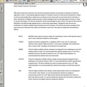
View attachment 12405
 

Attachments

  • isabel1.jpg
    isabel1.jpg
    153.7 KB · Views: 282
It heads out to a dirt road and I believe it goes thru private property after some distance.

Trail of doom is--after the hair pin turn--you go over 2 creek crossings and its the 3rd trail to the left.
 
ok so how do you get to the mines?


Could someone draw a line on the map i got where TofD is?

Is there a "current" map of the area. I have been following the maps you guys have been putting together and honestly, they suck. give me some of the GPS points and I can make a good map with all the crazy trails on it.
 
trail of doom is just a loop off of izzy. You could look at maps all day but if you really must know you have to run it :stirpot:
 
ok so then, what about these trails,
SOL
Grumpy Trail ??
Bonus Round
Worms Butt ??
Eat poop
Highrider

Where would you find these??
 
View attachment 12407
Is this the Trail of Doom?

I heard there is only one way in and you have to come back out the same way, is that true.

This might seem frustrating that I keep posting these but, If we can get these lesser known trails on a map, it would help greatly.

Possibly GPS data from some of these trails??
 

Attachments

  • TOPO!map1.jpg
    TOPO!map1.jpg
    43.2 KB · Views: 229
i guess ill just keep addin to my "map" im makin. It would be really cool if we could get some of the lesser known trails on the map that were mentioned earlier. I might take a drive up to reiter to get some of the lesser known trails like the one on the left of izzy tail right next to the hairpin turn.
View attachment 12410
 

Attachments

  • TOPO!map.jpg
    TOPO!map.jpg
    43.1 KB · Views: 203
I love you guys!! We ran a couple of trails with your group yesterday. Ran the Wall and played around there with you guys for a while. It was a blast.:beer:
 
Back on track...

were are these trails??
Does anyone know, or are they one of those, go up there and meet someone who already knows where the trails are and follow them kinda thing??
 
Well if your at the rockgarden entrance and look east the first power poll to the left is the entrance to grumpy trail,and if you head down the road heading west on your right hand side after the dip in the road is the trail Rinoland go up that alittle way's and there's a trail to your left that's poop trail..I'll look at the other trails your looking for and see if I know them
 
you know where sack up end's right??? well if you wanted to get back to the 2nd pit you would take a left out of there,but if you wanted to go too the mines you would take a right and follow the logging road up a couple switch backs you'll come too a T in the road either right or left but if you look straight you would find the first mine the 2nd mine is too the right about 50-100yrd's on your left....
 
sweet, I'll have to go up there and see all of these trails.
Are they fun? (for me, they dont have to be difficult to be fun:rolleyes: )

What about,
Highrider
worms butt
Slip and Slide ??
Upper Cut??
Bonus round?

Never heard of people running these. Are they just other names for trails I already know??
 
ya i heard that highrider was closed but i was just wondering about it. Where was it? Why did it close?
 
sweet, I'll have to go up there and see all of these trails.
Are they fun? (for me, they dont have to be difficult to be fun:rolleyes: )

What about,
Highrider
worms butt
Slip and Slide ??
Upper Cut??
Bonus round?

Never heard of people running these. Are they just other names for trails I already know??

Highrider is CLOSED and it's at sultanbason rd.. bonus round is at the Y left is the way too Isabel right is to the end of sackup go right 100-200yrd's up the road on your left is the beginning of bonus round..Alot of campers like to go there to camp so sometimes you can get in sometimes you can't their are other way's to get into bonus round but that will be the easiest..
 
i guess its gonna be kinda hard to map out trails ive never heard of/ been on.

Guess i gotta go up there with my GPS and hit some of the trails. On second thought what would you rate the trails "we" have been talking about? (Grumpy Trail, Trail of Doom, Rhinoland, etc.)
You think a Cherokee with a 4.5" lift rollin on 33s and open front and back could make them??
 
Top