You are using an out of date browser. It may not display this or other websites correctly.
You should upgrade or use an alternative browser.
You should upgrade or use an alternative browser.
"Wagons East!" Naches Pass Run - report (Oct 10th, 2009)
- Thread starter Ceg
- Start date
All Wheelers Off Road Club -
"Wagons East!" Naches Pass Run
October 10th, 2009
On Saturday October 10th, 2009 we meet up at the All Wheelers camp in Little Naches off FS1906 with 14 rigs.
We took NF19 and turned up FS1914.

We took Pyramid Pass over to the west side.


The trail only had a few wet areas.

At the top of the first climb we stopped to regroup.

Don broke his track bar on the way up.


Don headed home and we continued up the trail.

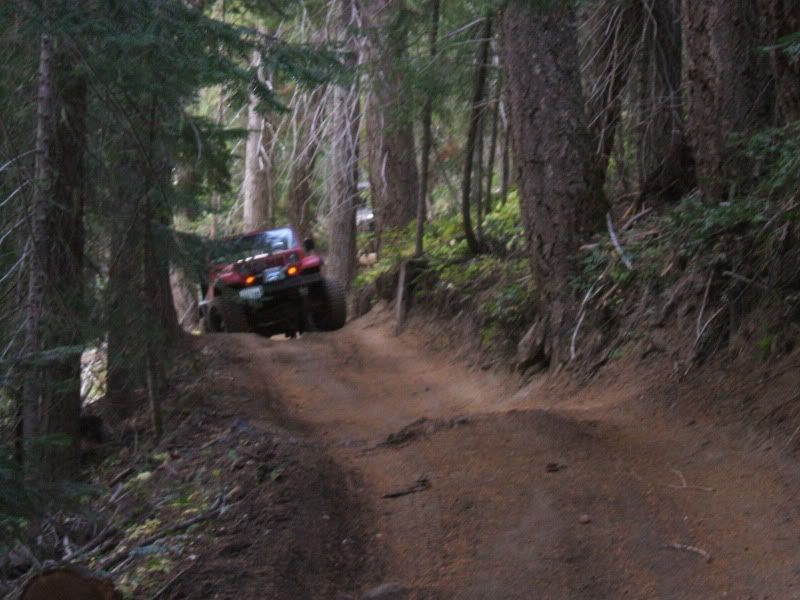
This mud hole seems to always be here all season.

At the Pacific Crest Trail we stopped for lunch and to see the sites.


After a short break we were back on our way east.


"Wagons East!" Naches Pass Run
October 10th, 2009
On Saturday October 10th, 2009 we meet up at the All Wheelers camp in Little Naches off FS1906 with 14 rigs.
We took NF19 and turned up FS1914.
We took Pyramid Pass over to the west side.
The trail only had a few wet areas.
At the top of the first climb we stopped to regroup.
Don broke his track bar on the way up.
Don headed home and we continued up the trail.
This mud hole seems to always be here all season.
At the Pacific Crest Trail we stopped for lunch and to see the sites.
After a short break we were back on our way east.

We passed a lot of rigs as we dropped down the east side.
We stopped as we crossed FS1914 to regroup.


This bridge is kind of weird with the zigzags.

This bridge has gotten a few rigs.


Regrouping on FS1913.


Wow, they rerouted the trail.

Wow is right! Holy crap. The new part of the trail is going to kill someone.
There is one area where the trail is too skinny without anything to stop you from rolling off the cliff.
The side of the trail seem to be falling off as we came through.
A quick stop after dropping back down to earth.


At the East Naches Pass Trail Head we regrouped to head back to camp.


Some of the people headed back home and some of us camped.
The night was really cold. My water lines in my camper froze. Some that tent camped left early in the morning.
The rest of us took our time about leaving. Havo's family headed out next.
Havo Jr came back to tell us that Hwy-410 was blocked by a landslide.
Test Dummy used Barbie's car to go get gas for his CJ and to find out what was going on.
Whistling Jacks had no power to sell gas and Squaw Rock ran out of gas the car before them.
Test Dummy found Havo and they were planning on wheeling out. Test Dummy planned to go back and get his CJ to follow them.
Test Dummy came back to camp to tell us what he found out. The people he talk to said there was a landslide over Hwy-410 and the river near the Nile.
They said the area was flooding and the only way out was going west over Hwy-410 or to wheel over Bald Mountain.
Jay gave Icesis some gas for his XJ so my wife could drive it over the pass.
I gave Test Dummy some fuel from my XJ for his CJ and some extra for Havo's group if they needed it.

Here we are turning to go to the west side.

Cayuse Pass was closed so we had to go all the way around through Enumclaw to get back to Selah.
Test Dummy could not find Havo so he headed west too. We ended up staying with Icesis in Kent.
My son "Doc" had an appointment at Children's Hospital so it worked out for us.
Test Dummy stayed and followed us across I-90 since he was driving his CJ.
We stopped at Indian John Rest Area to make sure Test Dummy's CJ was doing ok.

This was a great run with plenty of added adventure.
A special thanks to all the people that helped get everyone home.
zukkev
Cornfuzzled yet again...
Nice pics Ceg!!! Thanks for sharing!
Thanks.Nice pics Ceg!!! Thanks for sharing!
CentralGrand
Well-Known Member
Hey Clay I don't really see the danger?:eeek: Any other pics or description?
dessertrunner735
Active Member
On the naches trail?
Can't you go all the way to the sound on that trail? If so what are the trail maps that you need and gps headings ,that looks like a fun ride! Yea 410 gonna be down for awhile seeing how theres a .25 mile of crap in the way - wagons ho for sure! :d
Can't you go all the way to the sound on that trail? If so what are the trail maps that you need and gps headings ,that looks like a fun ride! Yea 410 gonna be down for awhile seeing how theres a .25 mile of crap in the way - wagons ho for sure! :d
The area where the trail is too skinny without anything to stop you from rolling off the cliff? To busy trying not to fall off to take pics.Hey Clay I don't really see the danger?:eeek: Any other pics or description?
Hwy-410 near Cliffdale to Hwy-410 near Greenwater.Can't you go all the way to the sound on that trail?
Thanks.That landslide SUCKS!
Nice write up:awesomework:
The landslide is bad. I feel for those who lost their homes. I hear the insurance companies are not covering crap.
benw1
Well-Known Member
The area where the trail is too skinny without anything to stop you from rolling off the cliff? To busy trying not to fall off to take pics.
That part has been there since the first time I ran the trail in '99. :scratchhead: You're talking about the section below rabbit holes where you climb up, traverse the skinny off camber section and the drop back down on the other side right?
That part has been there since the first time I ran the trail in '99. :scratchhead: You're talking about the section below rabbit holes where you climb up, traverse the skinny off camber section and the drop back down on the other side right?
Yup, but now you don't go thru the meadow before going up and around the river bend. They rerouted the trail thru the woods and put a little bridge just before you go up. The reroute is Jeep tight around trees that if you don't keep the turns sharp will put a wheel over the edge of the trail. The bare section at the highest point has a dip towards the river that's getting deeper all the time. A heart stopper! No frigging way would I attempt that section in the wet, but I always do it in the dry. It's the only place on the north side of FR19/410 that gets my heart racing so much.
Pic of Ryan coming out of the dip
Hey Clay I don't really see the danger?:eeek: Any other pics or description?
turn off the puter and drive your web-wheelin ass up there, ride-along king:flipoff:
It is new since I ran it in July of this year.That part has been there since the first time I ran the trail in '99. :scratchhead: You're talking about the section below rabbit holes where you climb up, traverse the skinny off camber section and the drop back down on the other side right?
The new section is above this old section;


I think this was where you would fall off to.
Last edited: