You are using an out of date browser. It may not display this or other websites correctly.
You should upgrade or use an alternative browser.
You should upgrade or use an alternative browser.
wheelin off highway 2
- Thread starter littleblue4runner
- Start date
Not true is you are on Forest Service property.Under the "New Travel Management" Plan. Open or closed signs are a thing of the past on the Mt Baker/Snoqualime. You must have the travel management map. The map shows open routes. All others are closed whether signed or not. Not having the map can result in a citation. Not being able to show the Ranger where you on the map are can result in a citation. Being on a road or trail not on the map can result in a citation. There is digression by the Ranger in the beginning of this but it won't last long.
This is the way of the future. The travel management plan is comming to all districts. The Mt Baker/Snoqualime is the first of them.
Info on this issue is here.
http://www.nw-wheelers.com/forum/showthread.php?t=54195
crash2
-Oh no I picked a side-
Thats right I forgot about that law or whatever you wanna call it.
Double edge sword for sure...
Double edge sword for sure...
Thats right I forgot about that law or whatever you wanna call it.
Double edge sword for sure...
No more "What Sign?" excuse. Now it will be "What Map?, "Where do I get one of them?" excuses. Followed by "You gotta be kidding.
Everybody please tell everyone you wheel with. Everyone must have the map. Not just the group leader or just someone in the group. Everyone!
crash2
-Oh no I picked a side-
For the record it looks like its rd 6320
http://www.fs.fed.us/r6/mbs/projects/travel-management/mvum_skykomish.pdf
http://www.fs.fed.us/r6/mbs/projects/travel-management/mvum_skykomish.pdf
littleblue4runner
Active Member
For the record it looks like its rd 6320
http://www.fs.fed.us/r6/mbs/projects/travel-management/mvum_skykomish.pdf
ok cool. so what i cant go there anymore? where do i go to get the map then? i was not the only one that was up there, there was tracks for a other truck with some big a$$ tires.
ok cool. so what i cant go there anymore? where do i go to get the map then? i was not the only one that was up there, there was tracks for a other truck with some big a$$ tires.
see post 22 :awesomework:
Boonie Buster
Stuck on a Curb
No more "What Sign?" excuse. Now it will be "What Map?, "Where do I get one of them?" excuses. Followed by "You gotta be kidding.
Everybody please tell everyone you wheel with. Everyone must have the map. Not just the group leader or just someone in the group. Everyone!
So according to these maps, if you come to a physical junction in the road and look at your map, will both roads be on your map? will the closed road have an "X" at the junction, or will it not even be existant on the map?
Because if closed trails/roads are omitted from the map, that would be by far the worst map ever created and the cartographer should be strung up by his little toe!

crash2
-Oh no I picked a side-
So according to these maps, if you come to a physical junction in the road and look at your map, will both roads be on your map? will the closed road have an "X" at the junction, or will it not even be existant on the map?
Because if closed trails/roads are omitted from the map, that would be by far the worst map ever created and the cartographer should be strung up by his little toe!
And thats what scares me and where this whole deal becomes a catch 22.
One one hand its great because it will help give the LEO's more ability to enforce and have things hold up in court.
But on the other hand if there is an error on the map or if they wanted to omit a road they can easily do this.
And thats what scares me and where this whole deal becomes a catch 22.
One one hand its great because it will help give the LEO's more ability to enforce and have things hold up in court.
But on the other hand if there is an error on the map or if they wanted to omit a road they can easily do this.
I havent talked with Arlene about this final version they came out with but this was a several year project in which we were given (and took) the oppertunity to make sure all of the roads and trails we use were on the map. We have had the same thing going on on all the the forests that the FS oversees. This was a very public process.
The_Shocker
Well-Known Member
- Joined
- Jan 21, 2009
- Messages
- 566
And thats what scares me and where this whole deal becomes a catch 22.
One one hand its great because it will help give the LEO's more ability to enforce and have things hold up in court.
But on the other hand if there is an error on the map or if they wanted to omit a road they can easily do this.
Easy answer: If it is "omitted" from their official maps then you likely should NOT be on that road/trail. :awesomework:
And again just because you are out and "find" a road/trail doesn't mean you are automatically legal to be there.

Boonie Buster
Stuck on a Curb
Another concerning (confusing) thing to me is the map legend. The double line roads say they're "Roads Open to Highway Legal Vehicles Only" ....yet there are little chunks of these roads out in the middle of nowhere, attached to a faint line road which is indicated on the legend as "Other Public Roads and Trails:" which then states....
So how is this to be interpreted? you can't drive out to this little strip of approved road via the road from the highway, so how is it to be used? :corn:
"These symbols are used to show routes the Forest Service
does not have jurisdiction over and has not designated for
motorized use. These symbols are part of the reference layers
showing connections to towns and cities outside the forest
boundary."does not have jurisdiction over and has not designated for
motorized use. These symbols are part of the reference layers
showing connections to towns and cities outside the forest
So how is this to be interpreted? you can't drive out to this little strip of approved road via the road from the highway, so how is it to be used? :corn:
crash2
-Oh no I picked a side-
I havent talked with Arlene about this final version they came out with but this was a several year project in which we were given (and took) the oppertunity to make sure all of the roads and trails we use were on the map. We have had the same thing going on on all the the forests that the FS oversees. This was a very public process.
What happens if a new map comes out and a road is erased from the map?
hwcurtice
Well-Known Member
So, if I'm reading this map correctly, and if memory serves me correctly as well, this road is beyond where that red Cherokee got stuck in the river/road a few months ago, right? Or is this before that?
And if I read what is being said here, and by looking at the map,reading the legend, using the road listed, 6320 is okay, being able to get to it is a no no.
Yes, I'm confused, not that I'm taking my Dakota up there anytime soon....
And if I read what is being said here, and by looking at the map,reading the legend, using the road listed, 6320 is okay, being able to get to it is a no no.
Yes, I'm confused, not that I'm taking my Dakota up there anytime soon....
Boonie Buster
Stuck on a Curb
To go with my post a couple back and I think it's along the lines of what HWCurtice is asking...
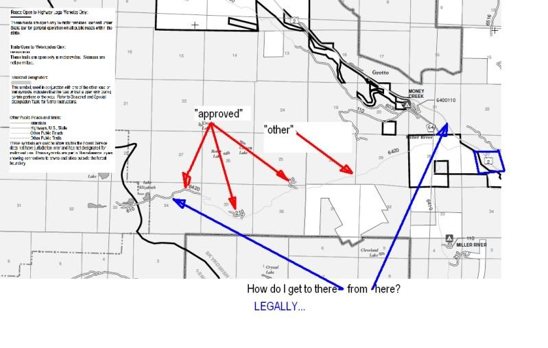
From what I saw on the map, if they don't want you on the road, the road won't be on the map. Roads that I looked for that were previously "grey area" are not on this map. From the legend, the thin grey line is an "other public road" which would make it legal to travel.
Last edited:
You have to pack your truck in like a hiker...
Cutting off access to the trail that's "OK" to be on is ****ing brilliant... Somebody got a raise for coming up with that...
Then again, can't these roads be grandfathered in??? Like a "right of way"???
Is this something that the PNW4WDA can fund and fight???
I may never use these roads, but if we can keep them open and learn from the experience for future engagements, that would be great... Being that the PNW4WDA has a lot more members, resources and hands on experience, I would like to see/help if there's something we can do legally...
Is there anything we can do at this point Jim???
Cutting off access to the trail that's "OK" to be on is ****ing brilliant...
Somebody got a raise for coming up with that...Then again, can't these roads be grandfathered in??? Like a "right of way"???
Is this something that the PNW4WDA can fund and fight???
I may never use these roads, but if we can keep them open and learn from the experience for future engagements, that would be great... Being that the PNW4WDA has a lot more members, resources and hands on experience, I would like to see/help if there's something we can do legally...
Is there anything we can do at this point Jim???
Boonie Buster
Stuck on a Curb
From what I saw on the map, if they don't want you on the road, the road won't be on the map. Roads that I looked for that were previously "grey area" are not on this map. From the legend, the thin grey line is an "other public road" which would make it legal to travel.
So they have omitted roads from the map....cool...Wait till someone gets lost and dies because they had a Forest Circus map without all the roads for landmarks to get back home... And when rescue crews go to search for them, they wont see a road on the map to potential drive down or reference as a landmark to search for the victim...:awesomework: This is a cool system.
They should probably take the lakes and rivers off the map unless the legal roads drive to them or across them via a bridge. Otherwise there is no reason to be there :awesomework:
Last edited:
What happens if a new map comes out and a road is erased from the map?
Yep, that could definetly be a possibility and a problem. This by no means is a great system but its the one they came up with and we get to deal with it. Its going to take a lot of diligenve to make sure that roads and trails dont just disappear.
Harvester of Sorrow
Well-Known Member
Then again, can't these roads be grandfathered in??? Like a "right of way"???
Is this something that the PNW4WDA can fund and fight???
I may never use these roads, but if we can keep them open and learn from the experience for future engagements, that would be great... Being that the PNW4WDA has a lot more members, resources and hands on experience, I would like to see/help if there's something we can do legally...
Is there anything we can do at this point Jim???
Nope...
2-1/2 to 3 years ago now (if I recall correctly) there were some meetings held in different districts regarding the new "Motorized Travel Plan". The first meetings were to tell everyone what was going to be happening and when.
They then gave everybody that was interested (WOW, PNW$WDA, horse clubs, hikers, etc.) a chance to chart and submit trails that they would like to see on the map. If you submitted it, it would be considered. If no one spoke up for a trail or area, it would automatically NOT be considered, and treated as if it didn't exist.
Some of us GPS'ed trails that we really thought should be "considered". Some of those trails/areas didn't make it.
We had our say...
The interesting thing is that this new plan is soon to be nation wide, yet it is hardly heard of until AFTER the maps are created and put into LAW.
Regardless of web presence, thoughts of club presence and representation, this is the kind of disconnect that occurs in our hobby. Over three quarters of our hobby's enthusiasts don't even understand what a green dot/marked trail system means...
They surely won't/don't understand what this map will mean.