• Help Support Hardline Crawlers :

AWORC - Naches Pass Trail Run Report (July 21st, 2007)

Status
Not open for further replies.
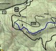
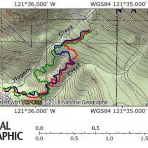
And I've seen past runs from a few groups that include that spot on thier ride. It TOTALLY looks like part of the trail. It isn't a bypass for something, it is WELL used, and there are no signs, or obvious shoe flys.

Unless you're misleading me with your description, and you may well be since this was your first time on the trail... That IS a part of "the" trail, but it is closed to motorized use. It has been signed in the past, and resigned. Someone keeps knocking the signs down, and you all know full well that just because the sign is gone doesn't mean it's suddenly open. You guys are not the first to go through there, either unknowingly or in total disregard.
 
It was a simple mistake I'm sure everyone has done something like it so just let it go. Now that everyone knows that this part of the trail is not for motor vehicles I'm sure EWOR wont do it again.
 
For all of you getting butt hurt over this, you're just proving me right by reacting like that. If you didnt' know you were in the wrong just admit it and apologize. No need to get all defensive.

:wtf: do you think I'm doing???:rolleyes:
My reaction is over you saying that we knew it was wrong and did it anyway. I have only wheeled down that side 4 times in my life. Once in 1989 when there were more of those cross trails open, July 29th 2006, October 1st 2006 and July 21st, 2007. Test Dummy only has been there 3 times with me. Last Saturday was Fatboy second time. The other 6 rigs had never been there in there lives. So NO one knew it was not part of the trail!

There were no signs and the trail there looked the same last year. For you to say there are new trails push through shows you are full of ****! You don't know as much as you think you do.

If have no right to slander us or our club. We fight hard to keep the trails open. We promote Tread Lightly and educate the guys that don't. We don't bash them as you are doing to us. If this is your way of educating then you are doing more harm than good. Get off your high horse and get a life.
You don't know where I was talking about originally, where I thought those pictures were taken. Odds were with that many rigs that at least one person had been on the trail enough times to know, if not then I was mistaken and am sorry for assuming such. I never meant to bash you, you are reading way too far into what I said.
 
You don't know where I was talking about originally, where I thought those pictures were taken. Odds were with that many rigs that at least one person had been on the trail enough times to know, if not then I was mistaken and am sorry for assuming such. I never meant to bash you, you are reading way too far into what I said.
Thank you. I will make sure to let everyone know the last part is closed.

I would be willing to help with closing it off if there is a work party.
 
It was a simple mistake I'm sure everyone has done something like it so just let it go. Now that everyone knows that this part of the trail is not for motor vehicles I'm sure EWOR wont do it again.

Thankyou. And thankyou Karl as well for working with me to figure out the facts and admitting to the mistake. None of us are perfect angels, I too have unknowingly ****ed up in the past but I learned from it. My mistake was losing the trail in 4' of snow and finding myself in a stream. I could have driven through and torn it up, but instead I winched out backwards to keep from doing any more harm. What did I learn? Don't listen to the guy who says the trail goes left of the tree.


I never intended for this to turn into a bitchfest. The pictures in question initially looked like a point further into the trail, but as more info came to light it just turned out to be an even bigger mistake than I suspected.
 
Thank you. I will make sure to let everyone know the last part is closed.

I would be willing to help with closing it off if there is a work party.

Other than new signage, I don't believe they will let us close it off with a blockage. It is still a portion of a foot/horse trail and we can't put out those users. It's a tough spot to deal with. :booo:
 
Other than new signage, I don't believe they will let us close it off with a blockage. It is still a portion of a foot/horse trail and we can't put out those users. It's a tough spot to deal with. :booo:
The next part of the trail is blocked and posted. How about don't the same thing?
 
The next part of the trail is blocked and posted. How about don't the same thing?

I'd have to look and see, haven't been down in that section for quite some time. It's ultimately up to the rangers though, we'll have to have a chat with them about it. I'll see if I can get some time this afternoon to give them a call.
 
So, please educate me as to where the above referenced area in question is? I'm somewhat familiar with the Naches trail, but am not exactly sure where this discussion is referring to?
 
I believe they are talkin about the teh spot at the beginning on hte west side. Where you go up the 70 road and left onto the Y of FS road then you take the right to start UP the trail and the trail also left and DOWN but that portion is closed. I could be wrong, but thats the way it was when I ran it.
 
I believe they are talkin about the teh spot at the beginning on hte west side. Where you go up the 70 road and left onto the Y of FS road then you take the right to start UP the trail and the trail also left and DOWN but that portion is closed. I could be wrong, but thats the way it was when I ran it.

Correct. Zip, see the map I linked earlier, it shows roads 70 and 7065. The section of trail west of 7065 and across 70 is closed to motorized use.

http://www.nwjeepn.com/Maps/Lwrnaches.pdf
 
Last edited:
Unfortunately I can't open links here at work, and will follow up tonight at home, but is this what they used to call driveline hill? Down the road where the original entrance was?

Thanks for the feedback
 
Unfortunately I can't open links here at work, and will follow up tonight at home, but is this what they used to call driveline hill? Down the road where the original entrance was?

Thanks for the feedback
I'm not sure of that name, never heard it before. It would make sense though. I'll convert it to an image and attach so you can see.

Grr, nwjeepn guys password protected the file. A cropped screenshot will have to suffice.
 

Attachments

  • Untitled-1.jpg
    Untitled-1.jpg
    62.5 KB · Views: 106
I'm not sure of that name, never heard it before. It would make sense though. I'll convert it to an image and attach so you can see.

Grr, nwjeepn guys password protected the file. A cropped screenshot will have to suffice.

Yes, just to the right of 'steep' at the sharp right hand turn, there's a short steep hill climb with a big hole at the top, this used to be the original route to that section of the lower Naches. Is this where you're saying is closed off?

This section also started just before the left turn at the Y also, and led into the hill climb

Thanks for the map it helps greatly
 
Last edited:
Yes, just to the right of 'steep' at the sharp right hand turn, there's a short steep hill climb with a big hole at the top, this used to be the original route to that section of the lower Naches. Is this where you're saying is closed off?

Thanks for the map it helps greatly

No, we're talking about the dotted line marked "pack" on the usgs topo data in that map. It's just to the left of the end of the blue line connecting 70 and 7065, barely a few hundred feet long in the real world.
 
Which steep are you talking about? Off to the right edge of that map? IIRC the road that leads up to that is closed off.
 
Yes, just to the right of 'steep' at the sharp right hand turn, there's a short steep hill climb with a big hole at the top, this used to be the original route to that section of the lower Naches. Is this where you're saying is closed off?
I think that was the way we when up Naches Trail in 1989. I was kind of lost when I came down the west end part last July. Nothing looked the same.

No Markers then or now. It is so much easier to know where the trails are on the East side of the past.
 
Last edited:
Booya!!! Bitches.

I just got off the phone with Susan at the Snoqualmie Ranger district office who is in charge of THAT portion of trail.

She looked at her maps and YOU ARE ALLOWED TO RIDE ON THAT PORTION OF TRAIL. She told me you can ride a motorized vehicle from the 70 ROAD ALL THE WAY Through.

I talked to her supervisor, Denny Cogland and he confirmed it. They didn't put signs there and never will.

Questions? Complaints? Thier number is
360-825-6585
Snoqualmie NF Enumclaw Office.

PS. For future reference, lets get the facts straight and go off THE RIGHT MAPS before we start yelling at eachother.

PPS. Kiss my ass, ****er.
 
Yes, just to the right of 'steep' at the sharp right hand turn, there's a short steep hill climb with a big hole at the top, this used to be the original route to that section of the lower Naches. Is this where you're saying is closed off?

This section also started just before the left turn at the Y also, and led into the hill climb

Thanks for the map it helps greatly

For future reference, I'll never use another nwjeepin map again. I'll be using the maps from the ranger stations.
 
Status
Not open for further replies.
Top