• Help Support Hardline Crawlers :

Isabel trail

Trainwreckinseattle

mr tool shed
Joined
Nov 2, 2008
Messages
10
Has anyone else been to the TOP of isabel lately?

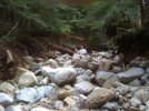
The road is impassable way before where the log bridge used to be.

Is this trail now dead or will work ever be done to fix it?

As bad as it is now I can only see it getting worse, MUCH worse.

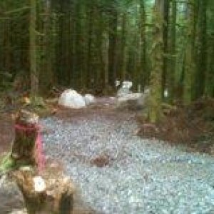
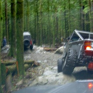
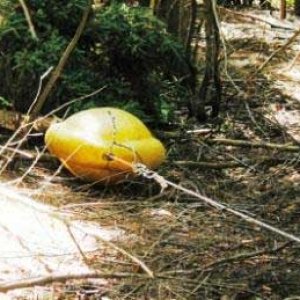
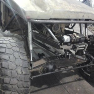
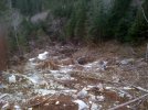
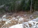
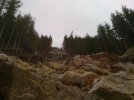
I went all the way up to the Mine last weekend. The destruction is BREATH TAKING. There is litteraly no picture or words to describe it. I have a bunch of pix in my profile with descriptions. After driving up as far as we could it took about 45 minutes of hiking before we reached the old mine. Which was the end of Isabel trail when it was passable.
 

Attachments

  • IMG_0109.jpg
    IMG_0109.jpg
    57.8 KB · Views: 1,025
  • IMG_0124.jpg
    IMG_0124.jpg
    61.2 KB · Views: 1,034
  • IMG_0127.jpg
    IMG_0127.jpg
    65 KB · Views: 1,028
  • IMG_0125.jpg
    IMG_0125.jpg
    39.4 KB · Views: 1,021
Last edited:
Looks like fun...

Impassable? Sounds like a challenge

From those pictures, it just suggests that your average rig isn't gonna do too well but for the folks with magic cars...no big deal :D
 
My "average" Toyota made it to within 100 feet of where the last peel out marks were from a "Magic car" Something very large had tried to make it up.

There isn't a wheeled vehicle that can make it even to where the bridge was !!!

A bull dozer or a track hoe might be able to make it with some moving of a few very large boulders and logs.

The trail used to be very easy up to the log bridge then was medium difficult the rest of the way to the top. So all that is now left is the easy part. My STOCK Toyota with a spool made it up to the point where the wash out is.
 
We've driven it all the way to the major blow down section (physically blocked) where the creek is running/diverted.

Issy is more fun now then ever :awesomework:
 
ALL the black tire marks, and scraped to hell rocks ended a little ways past that first huge rock that you have to climb where it FIRST gets real hard. Vehicles have only made it 1/5 of the way to where the log bridge was.

It only keeps getting harder and harder then it comes to a point just before the spot where the old log bridge was that is not passable without moving some car sized boulders, stumps and logs.

The first pic of me I'm standing up in a field of 3' tall 3,000 pound rocks. The pic was taken about the center point of where the trail gets hard and the blocked part where the bridge was. Not one tire mark to be seen !!!


How many wheelers have or are going to hike up farther and look to see what happened farther up?


Something tells me that you havnt been out wheeling with some of the buggy guys on here :eeek: do some searches back on here and look for the pics as to where they are :cool:
 
I know what buggies are capable of. I think a full on huge buggy might be able to make it up to where the bridge was. Then EVERYTHING comes to and end.

Untill you see the carnage you CAN'T understand. A couple months ago I made it almost all the way up to where the log bridge was. Unless you have been up there in the last few weeks you have no idea.

In this video you see the FIRST obsticle which is relatively easy. And as the person taking the shots says....the camera doesn't catch what it is actually like. You have to see it with you own eyes to fully understand.


http://www.youtube.com/watch?v=GuWL8YzYOy0&feature=related
 
Last edited:
The logs and crap in the first picture is new and probably needs to be cleared. Everything else I see in those pictures is old news and has been driven by many.
Most of that carnage is over a year old.
 
I know what buggies are capable of. I think a full on huge buggy might be able to make it up to where the bridge was. Then EVERYTHING comes to and end.

Untill you see the carnage you CAN'T understand. A couple months ago I made it almost all the way up to where the log bridge was. Unless you have been up there in the last few weeks you have no idea.

In this video you see the FIRST obsticle which is relatively easy. And as the person taking the shots says....the camera doesn't catch what it is actually like. You have to see it with you own eyes to fully understand.


http://www.youtube.com/watch?v=GuWL8YzYOy0&feature=related

It may come to end for you...but for us it's justing getting good :awesomework:

I crawled all that **** in your video w/o spinning a tire, plus, how do ya think all the trees were cleared out from across the trail up to the current river crossing...noob :rolleyes:
 
Trek, I'm glad you had a good day of wheeling and hiking......but isn't this information about the trail conditions old news? And as far as it being impassable, I don't disagree.......but you should see the **** us "buggy guys" can do on a good day. :;
 
The logs and crap in the first picture is new and probably needs to be cleared. Everything else I see in those pictures is old news and has been driven by many.
Most of that carnage is over a year old.

I was up there a couple months ago and it wasnt even close to how it is now. A couple months ago the lower May Creek crossing was still normal at the very begining of the trail. Now the creek bed sits 5 FEET lower. A new trail had to be blazed to cross the lower part of May creek.

Trek, I'm glad you had a good day of wheeling and hiking......but isn't this information about the trail conditions old news? And as far as it being impassable, I don't disagree.......but you should see the **** us "buggy guys" can do on a good day. :;

I hiked over/under logs, trees, and monster rocks. IF I can hardly hike over it how does a buggy make it up like cake?

I think you guys are thinking of last summer after the first wash out or a couple months ago when you were up there last.

I have a bright shiney quarter for anyone who shows me they can make that trail all the way to where the log bridge was. Like I said when we hiked up there wasnt even the hint of a tire mark, scratched rock, or rubbed off paint. But the first 100 feet sure had some painfull carnage marks left behind on the rocks !!!
 
I was up there a couple months ago and it wasnt even close to how it is now. A couple months ago the lower May Creek crossing was still normal at the very begining of the trail. Now the creek bed sits 5 FEET lower. A new trail had to be blazed to cross the lower part of May creek.


I hiked over/under logs, trees, and monster rocks. IF I can hardly hike over it how does a buggy make it up like cake?

I think you guys are thinking of last summer after the first wash out or a couple months ago when you were up there last.

I have a bright shiney quarter for anyone who shows me they can make that trail all the way to where the log bridge was. Like I said when we hiked up there wasnt even the hint of a tire mark, scratched rock, or rubbed off paint. But the first 100 feet sure had some painfull carnage marks left behind on the rocks !!!

I haven't made it yet(or tried since the last big storm). But the guys who have made it--had stickeys and you have to remember, stickey's don't leave the common rubber marks on rocks that lets say my SX's would..

Not saying I have personly seen somebody done it just the facts of it.
 
I haven't made it yet(or tried since the last big storm). But the guys who have made it--had stickeys and you have to remember, stickey's don't leave the common rubber marks on rocks that lets say my SX's would..

Not saying I have personly seen somebody done it just the facts of it.

I reject your reality and replace it with mine.

I understand that. And if you actually saw it you would understand. It is plain as day. Rocks get disturbed, scuffed, paint rubbed off onto, tire marks, it is very very very obvious that NO vehicle has made it more than a very short distance up past the start of the hard part. Then it goes to a part where half the damn mountain is in your way.

I'm done trying to explain this....... GO up there, beat your **** trying to get up 100 feet THEN GET THE FAWK OUT AND HIKE to see the mountain side wiped GONE !!! This is all recent as in the last month or two. Not from last spring. I'm not stupid, I run Isabel all the time. :rolleyes:
 
Last edited:
I'm not stupid, I run Isabel all the time. :rolleyes:


Yes you are and no you don't:rolleyes:


Jobless DROVE all the way to where the last log jam is w/the BIG boulder,on the edge of the 20' deep sink hole,in the middle of the trail. We had to stop clearing there because I broke the saw trying to cut the hanging,30" blowdowns overhead.That point is about fifty yards(at the most)shy of the old bridge location. Once cleared,the next 50 ft will be tricky(skirting the sink hole) but other than that, driving to with in 100yrds of the mine is easy.

I'm sure you'll argue because you don't know what the **** you are talking about:rolleyes:
 
I won't argue...... lets do it.


When, tell me I will be there !!!

As you said you have to clear it first. People have said it is passable. They havent seen it recent.

Once cleared of trees, and a lot of people have been up there stacking rocks (Which is already being done.... as seen in the videos in the other thread) some of the larger tired buggies might have a chance to make it.

But again........ Lets see it. You, Money, and anyone else, Crash? Show me how over blown I'm making this .... What are all you doing this week or Saturday?

Oh and Even I easily went around the SINK hole. I have been up Isabel 4 times recently.
 
Last edited:
I won't argue...... lets do it.


When, tell me I will be there !!!

As you said you have to clear it first. People have said it is passable. They havent seen it recent.

Once cleared of trees, and a lot of people have been up there stacking rocks (Which is already being done.... as seen in the videos in the other thread) some of the larger tired buggies might have a chance to make it.

But again........ Lets see it. You, Money, and anyone else, Crash? Show me how over blown I'm making this .... What are all you doing this week or Saturday?

Oh and Even I easily went around the SINK hole. I have been up Isabel 4 times recently.


put the pipe down... and chill mon. Either way... you ain't got the rig to run the fawker now anyways. :haha:


I think that area now needs to get MARKED off as a permanet EXSISTING trail as to not lose it for good. maybe everyone spend the day attaching cable to the downed trees to drag and lay them along the side and stack'em to show it's a used trail system. get something going thru there more to get a better set of tracks / trail marked off...

I agree on pictures / videos, they never do good justice to the actual sight of being there. that has got to become one of the best Washington trails around, once it's started to take shape and form.

:awesomework:
 
Treky, you know.....if you want to go wheeling with us, you don't have to challege us. All you gotta do is ask.:awesomework:

I'm taking the Grand Cherokee through there this Saturday the 7th. :redneck:
 
Top