zukkev
Cornfuzzled yet again...
How do you know they are the same people? Proof???
How do you know they are the same people? Proof???
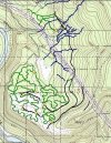
So this is my vision of what can be done at Reiter for the 4x4 trails
Green are trails
Blue is creeks
Yellow diamonds are skills areas
Black is access roads
White is Deer flats road
View attachment 43869
The only problem I see if how many people are going to be able to follow a map?
I like the trail idea Charlie, I see lots of trails. We can always improve them over time.
I think unless a flaging group is following a gps very closely then we are going to lose trail miles by just randomly flaging a trail.
Just a thought.
I like the map in the work party area better.
the idea would be for people with GPS's to lead the groups and get the way points from Charlie hoping they know how to use there GPS.
x2. yup, I'll be loading in Charlie's points into my GPS. every group will have at least one GPS person to tell us where we should be.
Why does anyone need a GPS or way points? Isn't the idea to find out where you want the trails to be?
I think the idea is to use charlies way points as a rough sketch/starting point/direction. He has done alot of homework why not use it...
Why does anyone need a GPS or way points? Isn't the idea to find out where you want the trails to be?
Who's idea?.....You don't need a work party to do that.
Who's idea?.....You don't need a work party to do that.

Honestly other in a couple rock piles there is nothing in the area to draw you to...
But since this is the DNR's show I would suspect the dnr...
Which is why I've already said I won't be there. I bring this up for other peoples interest as there's nothing in that area I wish to see.
wondering out in the woods is not going to get anything accomplished.
First we hired a trail planner to do this so WTF exactly are they doing.