Money Mark
Well-Known Member
- Joined
- May 19, 2006
- Messages
- 563
The DNR might come up with some kind of organization or presentation for the Concept 4x4 Trail Corridor, for the May 16th Reiter Work Party/Trail Marking
a. I believe we all agree that there are 3-4 different types of difficulty, a trail rating.
b. There are hours of mapping and information available to the DNR (nowires) that there are 6-7 miles of possible 4x4 Trail Corridor in Sections 1 & 2.
My idea:
Segregate:redneck:the groups that wish to view these trail corridor sections, based on proposed trail rating use. A group leader, with loaded GPS tracks in hand, will take the folks interested in viewing the "designated" Easy trail corridors and will walk it.
A group leader will take the folks interested in viewing the "designated" Moderate trail corridors and will walk it.
A group leader will take the folks interested in viewing the "designated" Hard/Expert trail corridors and will walk it.
Note: "designated" means nothing more than a suggestion. Ok?:hi:
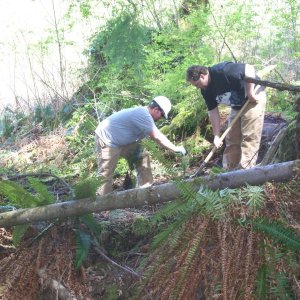
The volunteer work will be marking these 4x4 trail corridors with colored ribbons, on trees. There will be a larger group (leaders with GPS) that will clear this corridor of un-needed brush. There's a lot to do! and when we're done (I bet we could do it in 1 day) the actual and technical trail design (twists and turns, obstacle placement, etc) can begin. And after that, ready for submission of permits.......Or something like that.:redneck:
The alternative is run around in the woods aimlessly, yelling "this would be cool" and "hey, look at this". Waste of time if you don't know what you doing........trust me, I know.:;
I made this a poll.:corn:
PS. I have no interest in viewing the Hard/Expert corridors. I'll be GPSing and clearing the Moderate corridor.........the larger and longer of the 3.
a. I believe we all agree that there are 3-4 different types of difficulty, a trail rating.
b. There are hours of mapping and information available to the DNR (nowires) that there are 6-7 miles of possible 4x4 Trail Corridor in Sections 1 & 2.
My idea:
Segregate:redneck:the groups that wish to view these trail corridor sections, based on proposed trail rating use. A group leader, with loaded GPS tracks in hand, will take the folks interested in viewing the "designated" Easy trail corridors and will walk it.
A group leader will take the folks interested in viewing the "designated" Moderate trail corridors and will walk it.
A group leader will take the folks interested in viewing the "designated" Hard/Expert trail corridors and will walk it.
Note: "designated" means nothing more than a suggestion. Ok?:hi:
The volunteer work will be marking these 4x4 trail corridors with colored ribbons, on trees. There will be a larger group (leaders with GPS) that will clear this corridor of un-needed brush. There's a lot to do! and when we're done (I bet we could do it in 1 day) the actual and technical trail design (twists and turns, obstacle placement, etc) can begin. And after that, ready for submission of permits.......Or something like that.:redneck:
The alternative is run around in the woods aimlessly, yelling "this would be cool" and "hey, look at this".
Waste of time if you don't know what you doing........trust me, I know.:;I made this a poll.:corn:
PS. I have no interest in viewing the Hard/Expert corridors. I'll be GPSing and clearing the Moderate corridor.........the larger and longer of the 3.
Last edited: