-
Help Support Hardline Crawlers :
You are using an out of date browser. It may not display this or other websites correctly.
You should upgrade or use an alternative browser.
You should upgrade or use an alternative browser.
Reiter Stationing of the trails
- Thread starter nowires
- Start date
Binder
Well-Known Member
Why? Will this take place of the mapping the DNR plans to do?
crash2
-Oh no I picked a side-
Why? Will this take place of the mapping the DNR plans to do?
Needed data for obstacle placements...
Binder
Well-Known Member
Needed data for obstacle placements...
Why, Is there a purpose for this?
The DNR is going to map them in detail via GPS. This is the reason for all of the brushing and leg work. They need to get walking before they lose good weather and the brush grows back.
crash2
-Oh no I picked a side-
Why, Is there a purpose for this?
The DNR is going to map them in detail via GPS. This is the reason for all of the brushing and leg work. They need to get walking before they lose good weather and the brush grows back.
Actually stuff is getting ready to go dormant in about a month so we will be ok there.
Now correct me if I am wrong but GPS can't give slopes/angles of the ground correct? Thats what is being done at every stake.
Binder
Well-Known Member
Now correct me if I am wrong but GPS can't give slopes/angles of the ground correct? Thats what is being done at every stake.
Yes the GPS system they use gives altitude along with map. We should be able to use that data to get all the info needed to build obstacles.
crash2
-Oh no I picked a side-
Yes the GPS system they use gives altitude along with map. We should be able to use that data to get all the info needed to build obstacles.
But it won't give slope and GPS is not exact to the foot.
Regardless we are doing something that has not been done before and just wading our way thru it along with the DNR.
Agree or disagree its opportunity and will continue with what needs to be done.
I believe we (the users) are gathering the info for DNR to help speed up the process. If we leave it up to DNR it might get done sometime next year or maybe the year after...
With all that said I have an upgrade on Sunday so I will not be able to attend.
With all that said I have an upgrade on Sunday so I will not be able to attend.
crash2
-Oh no I picked a side-
So far count me in......
Dnr has tried the forestry grade GPS with no luck for the data that is needed. It is faster to just get the basic data that is requires under the US forest service trail building guide as discribed in the SEPA
The GPS was more of a PITA that is was worth. Either way the system that is being used goes fast.
We have now regressed to a string and compass :haha:
Any ways it looks like it is going to be hot that day. Does anyone want to start earler
The GPS was more of a PITA that is was worth. Either way the system that is being used goes fast.
We have now regressed to a string and compass :haha:
Any ways it looks like it is going to be hot that day. Does anyone want to start earler
zuk88
Well-Known Member
No earlier than 8 AM.I'm use to working out side in the heat so it doesn't bother me too much,as long as it wasn't like 2 Saturday nights ago :eeek:
Spanaway Mudder
Well-Known Member
- Joined
- Sep 25, 2007
- Messages
- 3,871
Something like this would help alot... I could probably help people get them at a cheaper cost....
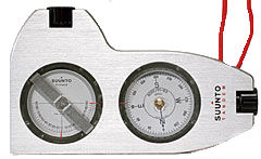
http://www.lengemann.us/suuntotandemcompassclinometercombo-azimuthcompasspercent-degreesclinometer.aspx:awesomework:
http://www.lengemann.us/suuntotandemcompassclinometercombo-azimuthcompasspercent-degreesclinometer.aspx:awesomework:
boardbysled
Tree Nerd.
Something like this would help alot... I could probably help people get them at a cheaper cost....
http://www.lengemann.us/suuntotandemcompassclinometercombo-azimuthcompasspercent-degreesclinometer.aspx:awesomework:
Meh, more worth it to just buy a regular Clino, as that compass is just about worthless. Can't set the declination, and can't site with it very easy. Or if your big-pimpin', ya use a Relascope.:redneck:
If I was on the wetside, I'd come out, as this is my kinda thing, but alas, I am not.
Spanaway Mudder
Well-Known Member
- Joined
- Sep 25, 2007
- Messages
- 3,871
Meh, more worth it to just buy a regular Clino, as that compass is just about worthless. Can't set the declination, and can't site with it very easy. Or if your big-pimpin', ya use a Relascope.:redneck:
If I was on the wetside, I'd come out, as this is my kinda thing, but alas, I am not.
I used that tool for installing lots of satellite dishes... you look thru the black piece with one eye and at the direction with the other if your good.. if not, you guess alot...:redneck:
Bronczilla
Project STINKY Superviser
Ill be there:awesomework:
Last edited:
crash2
-Oh no I picked a side-
Charlie is the one lane closure after the index turn off?
Charlie is the one lane closure after the index turn off?
Not really sure what is going on with that, but I know it will start monday sometime
crash2
-Oh no I picked a side-
Ya I just noticed it starts monday...
Ya I just noticed it starts monday...
It is funny, one set of signs say the 11th and the other says the 12th
For tomorrow I think I have everything but a compass. David was suppost to hook me up with a bunch of stuff and he got called off to a fire
One like this works great if anyone has one