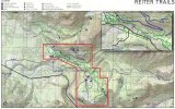
I'm sure it has much to do with all of the motorized use trails being up top and the lower area closing as the DNR only owns a very small piece down low......
Something funny....After the meeting before I was talking to Mark he was expaning to another guy about how great the rock face was and he would like to in the future incorporate the obstacle into the system. I pointed out to him that state parks owns it.

He replied that he didn't think state parks would open up their land to motorized use which is probably true....Wouldn't you think they would have been in contact with state parks and other neighboring land owners before now? Especially being they plan to incorporate land owned by others into the trail system.