• Help Support Hardline Crawlers :

Concerning IZZY

crash2

-Oh no I picked a side-
Joined
Mar 26, 2001
Messages
39,839
Location
Da gold bar
I am throwing this out there due to recent events concerning reiter as a whole..

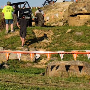
If you are heading up izzy and see folks walking along the trail, or spot something that doesn't look right. I susgest you don't venture up into where the trail turns fun..

The reason for this, is due to the eco folks who have been up there--one person thast casuing alot of havoc--is somebody who is EXTREEMLY pro wild sky. Once you get to where the trail gets fun--you have hit the buffer zone for the wild sky boundry and you only get deeper into that zone--and once across the creek you are into wild sky.

Now I am not sure what laws there are facing enting the area (And I assume its federal) but if you are caught--well your not going to like it..

I am just throwing this out there to help all of us keep from getting into any kind of trouble because I have seen it before with the TA area when those folks got busted...

So keep this is mind when you venture up there :awesomework:
 
Oh come on, Im not serious. The way the communist left (read democrats) are stealing from the liberty we've always enjoyed makes me wonder if there wont be a war between the left and the right some day.
 
I guarantee it. All the crap that has been going on up there makes this place info central.

I have yet to see anything used, that was taken from this site, or any other local site (can anybody prove me wrong). Everything that has happened has been from folks out in the field--on the ground...
 
I have yet to see anything used, that was taken from this site, or any other local site (can anybody prove me wrong). Everything that has happened has been from folks out in the field--on the ground...

What I'm saying is because of 4 wheeling sites, they know where to look. They lurk all the sites and find out where people will be wheeling. Then they go find something to bitch about.
 
What I'm saying is because of 4 wheeling sites, they know where to look. They lurk all the sites and find out where people will be wheeling. Then they go find something to bitch about.

But thats not even relevant in what we are dealing with....

Folks are there due to other actions--not web related chatter.
 
I suggest you don't venture up into where the trail turns fun...Once you get to where the trail gets fun--you have hit the buffer zone for the wild sky boundry and you only get deeper into that zone--and once across the creek you are into wild sky.

When you say turns fun...are you talking about after where the old log bridge used to be (point #3) on the Reiter Map? Or are you speaking of the huge mudslide everyone has been taking pics of? Shouldn't someone from the Federal Gov put signage up to mark the boundary? Seems a little odd to have a road in a roadless area. :eeek:
 
When you say turns fun...are you talking about after where the old log bridge used to be (point #3) on the Reiter Map? Or are you speaking of the huge mudslide everyone has been taking pics of? Shouldn't someone from the Federal Gov put signage up to mark the boundary? Seems a little odd to have a road in a roadless area. :eeek:


Below the bridge. I wanna say there is a 250' buffer zone on the rivere(where the wild sky boundry line is) and you really don't get that close to it where the trail was hit with water (near where that first lil rock ledge/stump used to be)
 
When you say turns fun...are you talking about after where the old log bridge used to be (point #3) on the Reiter Map? Or are you speaking of the huge mudslide everyone has been taking pics of? Shouldn't someone from the Federal Gov put signage up to mark the boundary? Seems a little odd to have a road in a roadless area. :eeek:

The fun part is like a couple hundred yards long and the "road" ends less then half mile from where the "fun" part starts
 
The fun part is like a couple hundred yards long and the "road" ends less then half mile from where the "fun" part starts

Are we talking about before or after where the old log bridge used to be? I assume before, based on posts from Mauler describing a rather large drop off when you get to May Creek. Am I close?
 
Are we talking about before or after where the old log bridge used to be? I assume before, based on posts from Mauler describing a rather large drop off when you get to May Creek. Am I close?


yes the fun part is a couple hundred yards before the log bridge or where it was
 
so I havn't been up it since the wash out but before you could still get to the bridge and keep going did the wash out divert the trail into the wild sky deal or is there something I'm not getting
 
Are we talking about before or after where the old log bridge used to be? I assume before, based on posts from Mauler describing a rather large drop off when you get to May Creek. Am I close?

Do you recall the lil camp spot on the left as you started getting to where the trail had exposed round rock starting to pop up (just where the trail started getting rocky)
 
Top